


Water Planning and Groundwater Management


 In the late 1800s, officials of Los Angeles, California, realized water availability would limit the growth of the city to a maximum population of 250,000. They solved that problem by undertaking what was then the world’s most ambitious engineering project—the Los Angeles Aqueduct—designed to secure future water supplies for the expanding city.
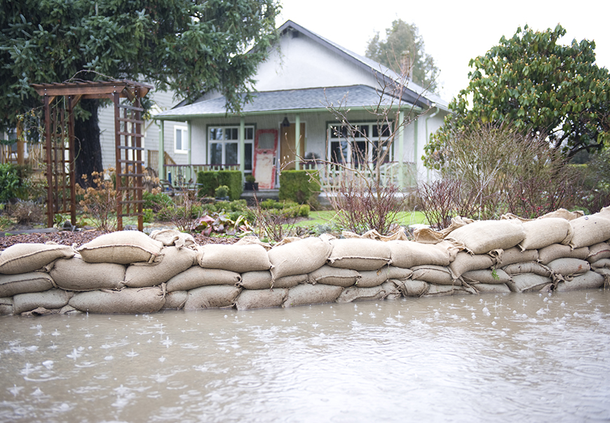
Now, lack of water looms as the ultimate limiting constraint to further growth in Texas. Many Texans fear that no one is planning to address those future shortfalls. However, Texas actually is in the forefront when it comes to systematically preparing to meet water demand in the future. Even so, challenges lie ahead as the state struggles to define and refine a legal infrastructure to resolve the issue of shortages.
To ensure water supplies, Texas legislators have devised an evolving water-planning process. Originating with local entities, the effort produces an updated statewide water plan that peers 50 years into the future every five years. Those plans estimate future demands for water, identify currently available supplies from specific sources, and forecast special needs (situations in which demands exceed supplies available during a drought of record). The plans then offer a menu of strategies to eliminate those needs. Local entities must allocate and augment existing water supplies to accomplish ends envisioned in the strategies.
Although parts of Texas have abundant surface water supplies, a provision in the Texas Water Code (TWC) designed to protect permit holders in each river basin makes it unlikely that surface supplies will play a significant role in dealing with shortages. Most of the strategies focus on prudent development and use of groundwater supplies. Locally controlled groundwater conservation districts (GCDs) play a pivotal role in the ongoing planning process. Texans concerned about water in the future should learn about the planning process and the important role assigned to GCDs to guide the fortunes of Texas.
GCDs are political subdivisions of the State of Texas designed to ". . . provide for conservation, preservation, protection, recharging, and prevention of waste of groundwater . . . and to control subsidence . . ." (Texas Water Code 36.0015). To accomplish that mission, each GCD operates under a board of directors consisting of at least five members. GCDs can make rules governing water usage designed to accomplish goals developed in the water planning process subject to landowners’ groundwater property rights. However, because they are under the jurisdiction of the Texas Water Development Board (TWDB) and the Texas Commission on Environmental Quality, GCDs do not operate entirely autonomously.
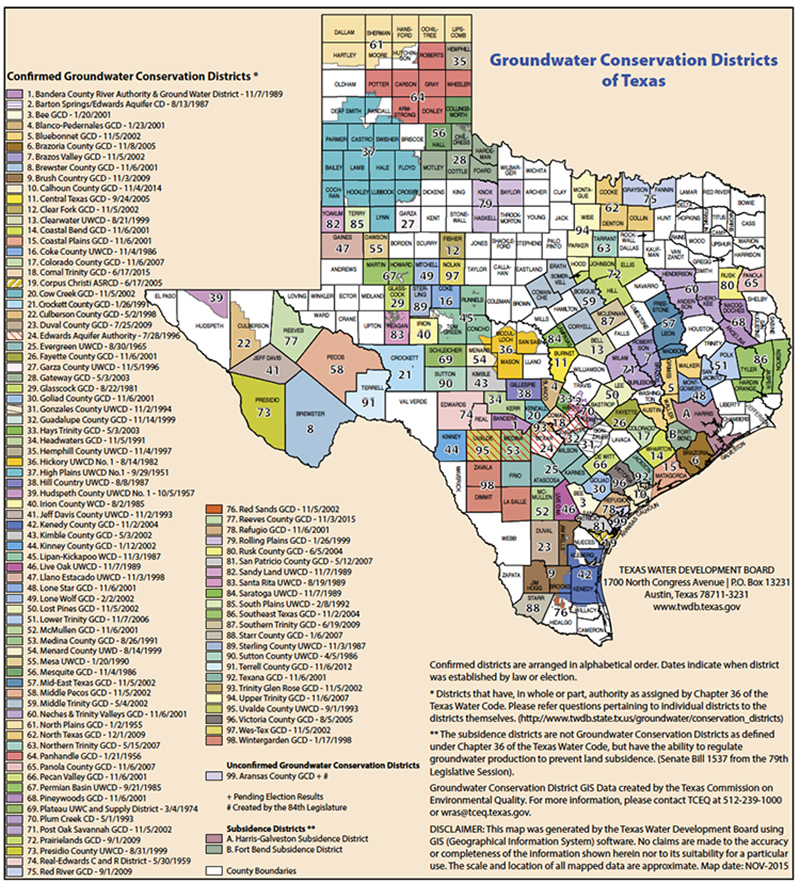
Beginning with the High Plains Underground Water Conservation District No. 1 in 1951, the current roster includes 99 districts, one of which is pending voter confirmation. The districts cover parts of 177 counties with 61 of those covering only one county and 39 extending over more than one county (Figure 1). All colored areas lie within a GCD while the white areas do not. Clearly, much of Texas is under the control of a GCD. However, many district boundaries lie largely along political lines while aquifers managed by GCD rules do not. Obviously, a patchwork of GCDs with independent boards guided by local whims could create a chaotic stew of rules reflecting varied visions of sensible water management.
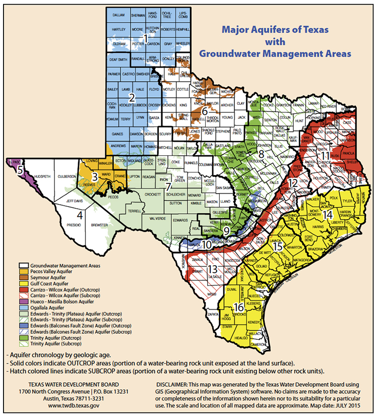
Attempting to achieve some consistency in management over shared aquifers, the water code specifies that all GCDs within a designated Groundwater Management Area (GMA) must meet to identify the desired future conditions (DFC) for each aquifer lying beneath those districts. As the GMA map reveals, GMA boundaries enclose multiple counties and outline all or parts of the major aquifers in Texas (Figure 2). Once every five years the GCDs included in each GMA must meet to establish DFC for each aquifer in the GMA. Two-thirds of the districts in the GMA must approve those conditions. The districts then must forward a report including the DFC and addressing the required steps in the adoption process to the TWDB. The board then studies the DFC to make sure they are reasonable and feasible. Once the TWDB deems the DFC to be reasonable, the GCDs officially adopt them. Those DFC form the foundation for the individual management plans and rules adopted by each GCD.
Within 120 days after adoption, an affected stakeholder can file a petition with a GCD to object to the DFC. That district must then contract with the State Office of Administrative Hearings (SOAH) to have a hearing to evaluate the reasonableness of the DFC in question. The GCD notifies TWDB to initiate a prescribed response from the board to the SOAH. The process unfolds under the guidance of an administrative law judge who considers specific evidence to reach a verdict. If petitioners remain dissatisfied with the SOAH outcome, they can file suit in district court.
Once established, GCDs must devise management plans to achieve the DFC in 50 years. Knowledge of the hydrology of the aquifers serves as the basis for groundwater availability models devised by TWDB to predict the total volume of water available in each aquifer. These hydrological model forecasts establish the modeled available groundwater (MAG) for each aquifer, and the GCD boards use the MAG estimates as they design rules that allocate water. Those rules must help to achieve the DFC established by the cooperative planning process. These action plans become part of the Regional Water Plan. Obviously, the official planning process differs from a perceived state-level, hands-off approach depending solely on Regional Water Planning Group decisions.
In fact, through the water code, the state does provide specific instructions that the local GCDs must observe as they discharge their duties. First, the code specifies that GCDs covered by the GMA must consider the following nine items as they devise DFC:
- aquifer uses or conditions,
- water supply needs and strategies included in state water plan,
- hydrological conditions,
- other environmental impacts,
- impact on subsidence,
- socioeconomic impacts,
- impact on private property rights (TWC 36.002),
- feasibility of achieving desired future condition and
- any other information relevant to specific desired future conditions (TWC 36.108).
Given these concerns and requirements to address these in the GMA report, the GCDs consult with TWDB hydrologists employing models of water supplies that consider situations in each district for every managed aquifer.
Initially, GCDs approached rule making with few constraints. However, Texas Supreme Court rulings have cast a pall over GCDs’ planning and rule making (Edwards Aquifer Authority v. Day and McDaniel [Tex. 2012] and Edwards Aquifer Authority v. Bragg [San Antonio 2013]). The Day case affirmed landowners’ rights to the water located beneath their land and ruled denying access to that water constitutes a taking of property and requires compensation. The Bragg case argued for compensation based on a partial denial of a permit for water. The plaintiffs prevailed in both cases. Obviously, GCDs might devise rules that bar landowners from pumping their groundwater. However, if they do so, they are vulnerable to a lawsuit demanding compensation. Legal experts believe that GCDs that allocate water on a fair-share basis to all landowners in the district will likely avoid liability in takings cases. Only time will tell which rules will pass muster.
Finally, the map of GCDs still contains an abundance of white spaces representing areas entirely subject to the rule of capture. Those areas are not covered by GCD rules nor are they included in the water-planning process. However, landowners located in those rule-of-capture areas may find themselves subject to legal and political action when they attempt to undertake ambitious projects like the Electro Purification project in Hays County (see Center publication 2103, "Marketing Texas Groundwater"). Ultimately, the Texas Legislature passed a bill extending the boundaries of the Barton Springs Edwards Aquifer Conservation District to cover wells planned in a rule-of-capture "white" area.
____________________
Dr. Gilliland ([email protected]) is a research economist with the Real Estate Center at Texas A&M University.
You might also like

TG Magazine
Check out the latest issue of our flagship publication.